
Polar air from beyond Greenland and Iceland has seen temperatures plummet across the UK, with the mercury dipping below zero in many regions.
As the UK braces itself for more wintry conditions, the Met Office has issued a second yellow weather warning for snow and ice.
The alert for ice in the East Midlands, London and South East England, Wales, and the West Midlands states clearing skies in the west in the early hours of Friday will allow a “rapid” fall in temperature, causing ice to form on untreated surfaces.
It continues: “A few showers of rain, sleet and hill snow will follow, possibly giving a slight covering of snow over higher ground.”
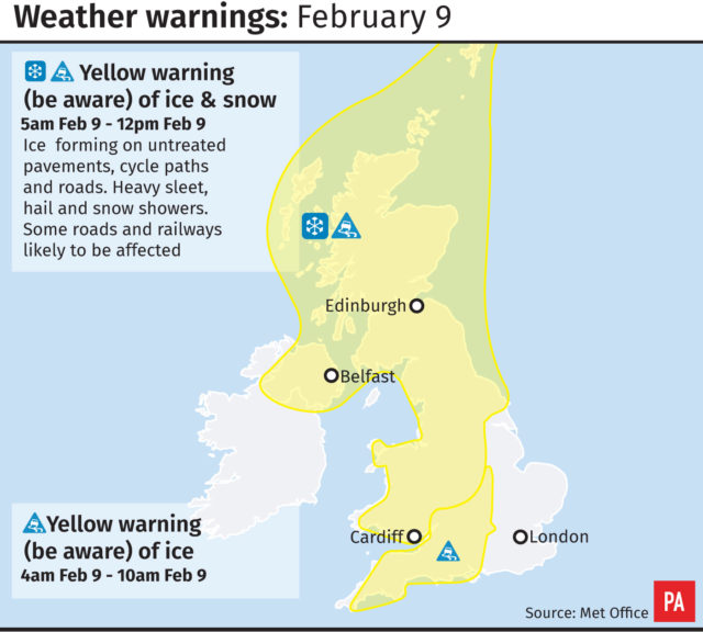
The severe snow and ice warning for the rest of the UK, excluding the far east, is in place until midday on Friday and states: “Rain and hill snow is expected to clear northwestern Scotland late on Thursday evening, and these clearer conditions will spread to all parts by early Friday morning.
“Ice is expected to form as skies clear. Heavy sleet, hail and snow showers will follow, and these will be most frequent across Northern Ireland, western Scotland, northwest England and by morning across Wales and the north and west Midlands.”
The Met Office said two to five centimetres of snow may accumulate above 100 metres, with some expected on lower ground too.
A milder start for many places this morning, but it's #cold across the southeast with temperatures widely below freezing. Santon Downham in Suffolk is currently at -6 °C ❄️ pic.twitter.com/SqzByDhbI5
— Met Office (@metoffice) February 8, 2018
At 5.30am on Thursday the coldest temperature of minus 6.4C (20.5F) was recorded at Shoreham Airport, while London saw an overnight low of minus 1.4C (29.5F).
Met Office meteorologist Martin Bowles said: “Over a few days we have been getting weather that is generally coming from northern parts, with some weather coming from Canada.
“At the moment it is called a Polar Maritime Air Mass which is coming from beyond Iceland and Greenland.
“So that is bringing in the cold air.”
He added that some of the colder temperatures experienced lately had also come from Scandinavia.


Comments: Our rules
We want our comments to be a lively and valuable part of our community - a place where readers can debate and engage with the most important local issues. The ability to comment on our stories is a privilege, not a right, however, and that privilege may be withdrawn if it is abused or misused.
Please report any comments that break our rules.
Read the rules here